
New Arctic Map Marks “Crucial Step” in Completing Mapping of Entire Ocean Floor Under Seabed 2030 (1)
Published on March 7, 2025

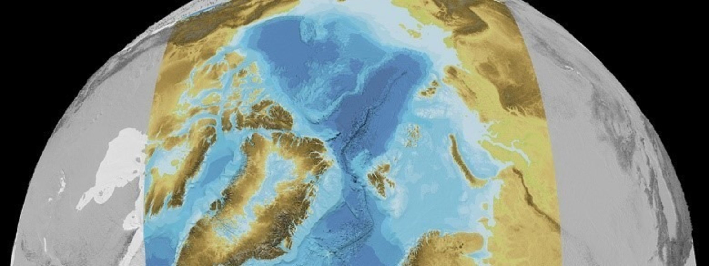
The Nippon Foundation-GEBCO Seabed 2030 Project announced on February 3 that a vast portion of the Arctic Ocean has been mapped out, adding some 1.4 million square kilometers of coverage-an area over three times the size of Sweden-to the global seafloor dataset.
This achievement represents a significant step forward in the mission to achieve a complete map of the world’s seafloor by 2030, offering an unprecedented level of detail for the Arctic Ocean, said Seabed 2030 in releasing their fifth and latest version of the International Bathymetric Chart of the Arctic Ocean (IBCAO).
It also provides vital insights for researchers and policymakers, contributing to safer navigation and more effective ocean exploration.
Established in 1997, IBCAO has long been the authoritative source of bathymetry for the Arctic Ocean, with the latest version-also published in Scientific Data by Nature-representing a quantum leap in detail, with a grid-cell size of 100 x 100 meters, compared to 200 x 200 meters in the previous version.
This achievement was made possible through advanced compilation methods, including the use of cloud-based distributed computing and the integration of metadata.
The release also highlights the challenges and innovations associated with mapping the Arctic Ocean, where perennial sea-ice cover and extreme conditions have traditionally limited data collection. Overcoming these obstacles has required groundbreaking technology and international collaboration.
Mr. Martin Jakobsson, co-head of Seabed 2030’s Arctic and North Pacific Regional Center, commented: “The release of IBCAO Version 5.0 is a testament to the collaborative effort of the Arctic research community and our dedication to overcoming the challenges posed by the extreme Arctic environment. This dataset not only furthers our understanding of the Arctic seabed, but also exemplifies the power of teamwork in advancing global knowledge.”
Seabed 2030 Project Director Jamie McMichael-Phillips said: “This release underscores the importance of regional initiatives like IBCAO in helping us achieve our goal of a fully mapped ocean floor by 2030. It represents a crucial step towards making essential data accessible for sustainable ocean management.”
Seabed 2030 is a collaborative project between The Nippon Foundation and the General Bathymetric Chart of the Oceans (GEBCO), which seeks to inspire the complete mapping of the world’s ocean by 2030, and to compile all the data into the free and publicly available GEBCO global ocean grid.
The project is formally endorsed as a Decade Action of the UN Ocean Decade. GEBCO is a joint program of the International Hydrographic Organization (IHO) and the Intergovernmental Oceanographic Commission (IOC), and is the only organization with a mandate to map the entire ocean floor.
On the occasion of World Hydrography Day on June 21, 2024, the Seabed 2030 project released the latest GEBCO Grid figure, showing 26.1% of the world’s seabed has now been mapped. (The figure did not include the latest release of the Arctic Ocean mapping.)
The new release not only provides a previously unseen level of detail in seabed mapping, but also offers vital insights for researchers and policymakers, contributing to safer navigation and more effective ocean exploration.
At the same time, researchers will be able to better monitor how marine life and habitats change over time. Furthermore, seafloor mapping can lead to the production of more accurate global prediction models, enhancing our ability to forecast weather, climate, and even tsunami impact zones.
(To be continued)